
History of Land Title in America
How land in America came to be surveyed, described, and insured
A brief history of land and locating it in the United States of America, how courthouse records make land ownership work, and an explanation of title insurance.
A note on this document: This reference was compiled from SKLD's archives, and portions of it were written decades ago. The description of courthouse practice reflects the paper-and-microfilm era in which it was written; see What Has Changed for how those offices operate today. For SKLD as it is now, see About SKLD Information Services.
The Puzzle in Your Deed
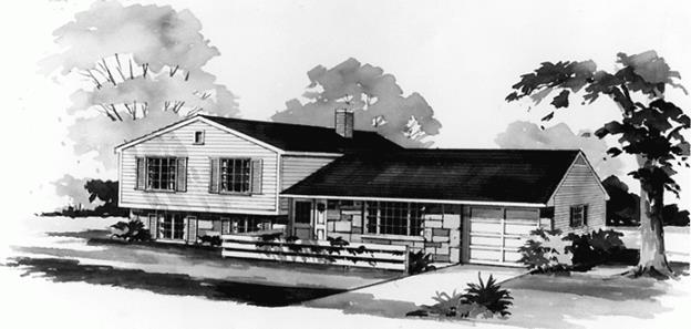
Joan was telling her friend how excited she and her husband John are about the new home they bought for $100,000. She described it as a beautiful tri-level with white bricks in the front, three large bedrooms, and the kitchen that she's always wanted (Fig. 1). But the deed that John and Joan received from Showcase Home Builders described:
Lot 4 in the Resubdivision of Lots 1 thru 12, inclusive, in Block 1 of Warner's Subdivision of the Southwest ¼ of the Southeast ¼ of Section 36, Township 2 South, Range 67 West of the Sixth Principal Meridian, in Adams County, Colorado.
Actually, John and Joan bought a lot — a parcel of land — and it was improved with the beautiful home that Joan described. The building and the other fixtures — driveway, patio, and swimming pool — made the value of the lot worth $100,000.
Most of us pay little attention to the legal description of the property upon which our homes stand. Terms like resubdivision, subdivision, section, township, and range are meaningless to the average home buyer. They may also be confusing to newcomers to the title business who have not had courses in real estate.
The pages that follow take that description apart, back to front. They explain where the section, township, and range came from; how a subdivision and then a resubdivision were laid over them; how the resulting deed became a public record; and why John and Joan were wise to insure the title they received.
How Land Came to Be Surveyed
The Colonial Problem
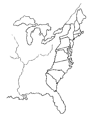
In 1492, Columbus reached the Americas. Over the next three centuries, shiploads of colonists landed along the eastern shore of North America. Thirteen colonies were established, and land was granted, bought, sold, and exchanged (Fig. 2).
A legal description for the sale of land was very sketchy in the colonial days, unless the land was part of a subdivision. A subdivision is an area of land represented on a map placed in the public records, indicating a designated number for each individual area drawn thereon.
Large areas of land are called tracts, and when formally represented as subdivisions, the maps of such areas are called plats. Individual areas drawn on a plat are numbered and labeled as blocks. If smaller areas are drawn within a block, they are numbered and labeled as lots.
Tracts of land that did not lie within the boundaries of a subdivision were difficult to describe in the colonies. A typical description — what a surveyor calls a metes and bounds description — might start out: "Beginning in the middle of the white pine stump standing on the west side of Simon Cook's land, and on the north side of the road that leads to the new city," and so on. Such a place of beginning probably doesn't exist today.
A New System for a New Nation
After independence, the western lands that the states ceded to the new federal government — beginning with the territory northwest of the Ohio River — became the public domain. Later acquisitions were added to it: the Louisiana Purchase in 1803, Florida in 1819, the Oregon Country and the Mexican Cession in the 1840s, and Alaska in 1867. Thomas Jefferson was instrumental in designing a new system for describing land that is not included in a subdivision plat. Established by the Land Ordinance of 1785, it would become known as the Rectangular Survey System, and is called the Public Land Survey System today.
Thirty of the eventual fifty United States would be governed by this survey system. The other twenty retained direction over surveys of lands within their boundaries upon admission to the Union. This means that unsubdivided lands in those states are linked together by independent surveys. To have imposed the Rectangular Survey System on them would have created endless disputes over boundary lines, since land had already been bought and sold for years on the strength of earlier descriptions.
Where the Rectangular Survey Applies
Governed by the Rectangular Survey System (30)
- Alabama
- Alaska
- Arizona
- Arkansas
- California
- Colorado
- Florida
- Idaho
- Illinois
- Indiana
- Iowa
- Kansas
- Louisiana
- Michigan
- Minnesota
- Mississippi
- Missouri
- Montana
- Nebraska
- Nevada
- New Mexico
- North Dakota
- Ohio*
- Oklahoma
- Oregon
- South Dakota
- Utah
- Washington
- Wisconsin
- Wyoming
Surveyed independently by the state (20)
- Connecticut
- Delaware
- Georgia
- Hawaii†
- Kentucky**
- Maine
- Maryland
- Massachusetts
- New Hampshire
- New Jersey
- New York
- North Carolina
- Pennsylvania
- Rhode Island
- South Carolina
- Tennessee
- Texas†
- Vermont
- Virginia
- West Virginia
* Ohio was the proving ground for the system. Much of the state was laid out under earlier and competing schemes — the Seven Ranges, the Virginia Military District, the Connecticut Western Reserve — before the rectangular survey was regularized.
** In Kentucky, only the Jackson Purchase in the western part of the state was surveyed under the rectangular system.
† Texas and Hawaii are the two states outside this group that were not carved from the original colonies. Texas kept its public lands on annexation in 1845 and surveyed them under its own system; Hawaii's land divisions descend from the Kingdom of Hawaii.
Principal Meridians and Base Lines
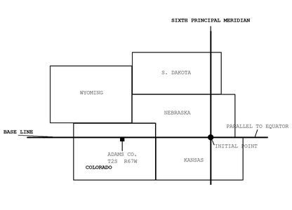
In 1785, a committee headed by Thomas Jefferson set the system in motion, and surveyors were sent out to establish the rectangular lines. It would be a continuing project for the next hundred years, moving from territory to territory, and renewed with the acquisition of Alaska, where some lines were established as recently as 1956.
Thirty-seven principal meridians, each with its base line, were eventually established. These lines formed the framework upon which the rectangular surveys would be laid out across the country.
Shown above is the Sixth Principal Meridian, which governs the surveys of Colorado — and of Kansas, Nebraska, Wyoming, South Dakota, and parts of Montana and North Dakota besides. A meridian line runs from the North Pole to the South Pole, but must pass through a permanent monument on the earth. That monument, called the initial point, stands on what is now the Kansas–Nebraska border, at 40° north latitude and 97°22′ west longitude. Base lines are established perpendicular to a meridian and parallel to the equator; this base line is the fortieth parallel, which crosses Colorado a little north of Denver.
Of course, the surveyors didn't draw lines on the ground. They placed monuments, usually an iron pipe, into the ground to extend the course of these lines from point to point. The placement of each monument was fixed by an astronomical reading.
The Twenty-Four-Mile Grid
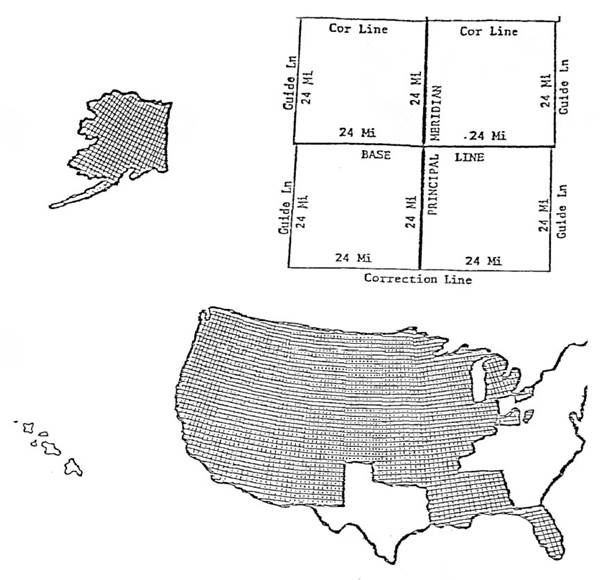
From each principal meridian, guide meridians were established both east and west. These lines run due north from points along a base line, or correction line, at 24-mile intervals. Notice that these guide lines converge with the principal meridian, since all of them meet at the North Pole. This necessitated the location of correction lines at 24-mile intervals, both north and south of the base line. These correction lines were established at points along the principal meridian, perpendicular thereto and parallel to the base line.
Shown above is the 24-mile grid formed by these lines, laid across those states governed by the surveys. Each square represents an area of approximately 576 square miles; notice the appearance of the areas in relation to the curvature of the earth.
Townships
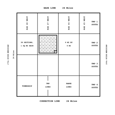
Areas of some 576 square miles proved too large in which to describe and locate a tract of land. Therefore, each area was surveyed into sixteen 6-mile squares, called townships. The north and south boundary lines of the townships are called township lines; the east and west boundary lines are called range lines. Each township is distinguished from every other by the range in which it lies, east or west of a principal meridian, and by its position north or south of a base line.
Because the range lines converge as they run north, the north line of a township is shorter than its south line — by roughly fifty feet at the latitudes of the middle states, and by more the farther north one goes. A township is therefore not a perfect square, and contains an area of slightly less than 36 square miles.
The township shown in Fig. 5 is Township 2 South, Range 67 West: two townships south of the base line, and sixty-seven ranges west of the Sixth Principal Meridian. It lies in Adams County, Colorado.
Sections
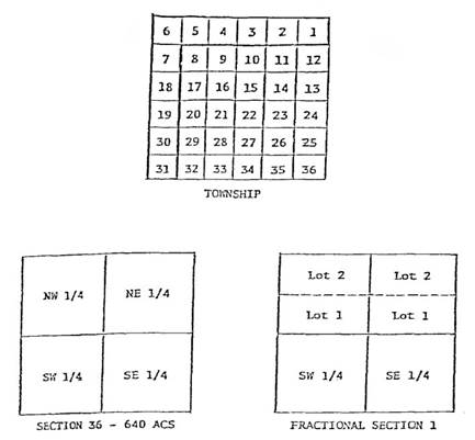
Even the area of a township proved too large in which to pinpoint a tract of land. In 1796, the Congress of the United States passed an act directing that townships be surveyed into thirty-six sections. Each section should be, as nearly as possible, one mile square and contain 640 acres of land. They should be numbered consecutively from 1 to 36, beginning with number 1 in the northeast corner of the township, proceeding west and east alternately through the township, and ending in the southeast corner with number 36.
Again, because of the curvature of the earth, it is not possible for all sections to contain 640 acres. Those that do not are referred to as fractional sections. In some areas a section is partially displaced by a river, lake, ocean, or reservation, and it too is referred to as a fractional section.
Since a township could not be surveyed so as to form 36 identical sections, as to shape and area, the Government Surveys provided for the deficiency or excess of footage in this manner. Any deficiency or excess occurring in the measurements from south to north was deducted from or added to the north row of sections, being sections 1 through 6. A deficiency or excess occurring in the east-to-west measurements was deducted from or added to the row of sections on the west, being sections 6, 7, 18, 19, 30, and 31.
Quarter Sections and Quarter-Quarters
There were periodic modifications to the Government Survey plans, eventually providing for the division of each section into a NE ¼, NW ¼, SW ¼, and SE ¼. It was intended that each of these quarter divisions would contain 160 acres. In fractional sections, as many of such divisions were made as possible, with the remaining portion divided into lots designated as Government Lots.
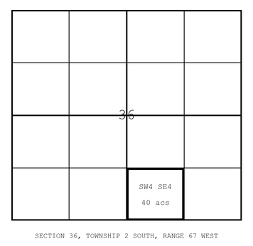
In 1832, the Congress of the United States directed a final division of the sections into quarter-quarter areas of 40 acres each. By giving the area in question, the section number, the township number north or south of the base line, and the range number east or west of the controlling meridian, a given tract of land can be located by the Rectangular Survey System.
Shown in Fig. 7 in bold outline is the Southwest ¼ of the Southeast ¼ of Section 36, Township 2 South, Range 67 West of the Sixth Principal Meridian. It is the only 40-acre tract of land in the United States with that combination of section, township, range, and meridian. It is located in Adams County, Colorado.
How Land Came to Be Described
From Patent to Plat
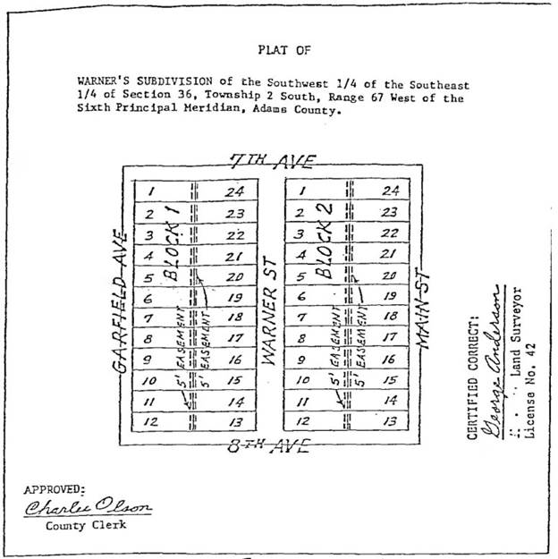
Title to the land owned by the United States Government was granted to individuals by a patent. William Warner became the owner of the 40 acres of land by a succession of deeds from the patentee. He decided to subdivide the land into lots and blocks, and to sell the lots for home sites.
Shown above is the Plat of Warner's Subdivision. It had to be approved by the County Clerk of Adams County as to its compliance with zoning laws and building restrictions. The plat must indicate a means of access to each lot, and any easements that are being established.
A subdivision is a profitable venture for the owner and the county alike. The owner profits from the sales of homes and home sites, and the county receives greater tax revenues from the developed land.
Resubdivisions
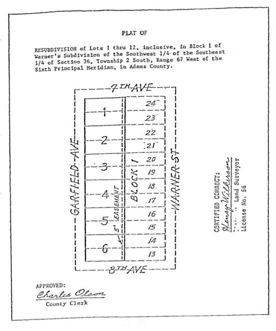
Showcase Home Builders bought Lots 1 through 12 in Block 1 for the purpose of resubdividing the area and building more expensive homes on larger sites.
Now we see the Plat of Resubdivision of Lots 1 through 12 in Block 1, and it too must be approved by the county clerk.
It was Lot 4 in this resubdivision that John and Joan bought from Showcase Home Builders — and, as it happens, they made sure that their title was protected by a title insurance company.
Condominiums

A different form of ownership rises from the same ground: the condominium (Fig. 10).
Buyers purchase units in a development and receive a percentage of the title to the land on which the condominium is built. Buyers are granted rights to building facilities, and share the real estate tax assessments as well as the expense of property maintenance. Title and assessments are in proportion to the size of the unit. Condominium developments are subject to state and local regulations; in Colorado they are created by recording a declaration together with a condominium map.
How Land Is Described Today
Subdivisions make it very simple to describe land in a deed of conveyance. The legal description need only mention the lot and block and identify the subdivision in question. The same holds for resubdivisions — and, as the term suggests, a resubdivision creates larger lots out of smaller lots, or smaller lots out of larger ones.
Units in condominium developments can be described by referring to the unit number and identifying the development.
Unsubdivided land in those states governed by the rectangular surveys is relatively easy to describe. The description pinpoints the tract to a particular section, or portion thereof. Where the tract does not correspond to a standard aliquot part, it is then defined by a metes and bounds description. This means the description must begin at a point that can be readily identified; then, after reciting the courses and distances from point to point around the tract, it must return to the point of beginning.
In states not governed by the rectangular surveys, unsubdivided land is more difficult to pinpoint into a specific area. Descriptions must refer to prior independent surveys, existing subdivisions, highways, or a well-known and established monument that can be relocated with certainty. The tract is then similarly defined by a metes and bounds description.
How Ownership Is Recorded
A description locates land. It does not, by itself, establish who owns it. That is the work of the public records kept at the county courthouse. Every deed, mortgage, lien, easement, decree, and tax record affecting a parcel is filed there, and together they form the chain of title — the succession of interests running from the government patent to the present day.
A title company does not search those records from scratch each time. It maintains a title plant: a privately held, continuously updated copy of the county's recorded documents, re-indexed by property rather than by party name, so that everything affecting a given parcel can be assembled in one place. Building and maintaining a plant is what makes a title search practical at all. The offices described below are where its raw material comes from.
Recorder's Office
Title plants are built from information submitted and recorded in the Recorder's office. Individuals, title companies, businesses, and governmental offices send documents in for a process called recording. To record a document, it is deposited at the office of the county recorder in the county within which the property is located. The recorder then endorses upon the instrument the proper identifying number (a reception number, and in most counties a book and page) in the order in which it is deposited, the date, hour, and minute of its reception, and the amount of fees for recording. The recorder also indexes the document by party names, preserves a copy for the public archives, and returns the original to the sender. Certain instruments may also be filed with the recorder, such as incorporation papers, financing statements, and the like. The difference between filing and recording is that a filed document remains in the custody of the recorder, while a recorded document is returned to the party interested in the property.
Documents affecting real estate must become part of the public records maintained by the county recorder in order to hold up against later purchasers. If a document of conveyance is not recorded, it is void as against a subsequent purchaser of the same property in good faith, for valuable consideration, and without actual notice of the prior conveyance, once that subsequent purchaser records. The precise rule varies from state to state — recording statutes are classed as race, notice, and race-notice — so the effect of a delay in recording is not identical everywhere. Title companies use copies of these recorded documents to maintain their title plants.
Clerk's Office
The County Clerk is charged with the care and custody of all books, records, maps, papers, plats, and the like affecting the title to real property. The Clerk's office also keeps files of divorces, judgments, probates, and other court cases in which the final outcome must become part of the public record. Title companies use those records which pertain to real property. Abstracts of these records appear in the document images in most counties. Many counties combine the Clerk's and the Recorder's office, because the duties are so similar.
Assessor's Office
The Assessor determines the value of every piece of property in the county for taxation purposes. To do this, most assessors keep a set of maps and indexes. These maps, continually updated, are drawn to scale and show each individual parcel with an identifying number. Title companies obtain copies of these maps for use as research tools where available. The assessor's index, updated annually, is organized in most counties by property owner name, street address, and parcel number, and carries assessed values, tax amounts, and legal descriptions.
Treasurer's Office
The County Treasurer collects general taxes using the information provided by the Assessor's office. The Treasurer's office also sends documents dealing with delinquent taxes, and with sales of property for back taxes, to the Recorder's office.
County Commissioners
County Commissioners are elected officials responsible for the overall governing of a county. Many of their decisions — setting tax rates, subdivision rules, and zoning — affect real property and, as a result, affect the county's title records.
What Has Changed
The practices described above were set down when the county record was a paper-and-microfilm record. The structure has not changed — documents are still deposited, numbered by reception, indexed, and returned — but the medium has. Most Colorado counties now accept electronic recording and return recorded documents electronically, and they publish indexes and document images through online search portals. Assessor information that once arrived as annual microfiche now comes as data files or through public parcel-search sites. Title plants that were once cabinets of film are now databases.
What has not changed is the reason the courthouse matters: an interest in land that is not in the public record is an interest that a later purchaser may never learn of — and may not be bound by.
From the Record to the Policy
Between the courthouse and the closing table sits the work that title companies actually do. It has three stages.
The Search
A title search assembles, from the plant and the public records, every instrument that affects the parcel: the patent, the deeds in the chain of title, mortgages and deeds of trust, easements and rights of way, covenants and restrictions, liens for taxes, judgments, mechanics' liens, and any court proceedings — probates, divorces, bankruptcies, foreclosures — that could have moved title or clouded it.
The Examination
An examiner then reads what the search produced and forms an opinion: who owns the property, what encumbrances run with it, and what must be cleared before the transaction can close. Gaps in the chain, ambiguous descriptions, and liens that were paid but never released are identified at this stage.
The Commitment
The result is a title commitment — the company's undertaking to issue a policy once stated conditions are met. Schedule A states the property, the estate or interest, the record owner, and the amount and type of policy. Schedule B states the requirements that must be satisfied before closing, and the exceptions: the matters the policy will not cover. Reading Schedule B is how a buyer learns what is actually being insured, and what is not. When the transaction closes and the requirements are met, the commitment becomes a policy.
How Ownership Is Insured
Title insurance is legally defined as a "contract of indemnity against loss or damage arising out of defects in or liens upon the title to real property."
More practically, it is a contract between an underwriter — a title insurance company — and its customer, guaranteeing the customer against monetary loss, up to the face amount of the policy, that would result from a title dispute. The policy states the description of the insured real property, the name of the insured party or parties, the name of the owner or owners, the amount of the insurance, and a list of items against which the company does not insure.
Owner's and Lender's Policies
Two policies are commonly issued in the same transaction, and they are not interchangeable. A lender's policy protects the lender's lien, in the amount of the loan; its coverage declines as the loan is paid down, and ends when the loan is satisfied. An owner's policy protects the buyer's own interest, in the amount of the purchase price, and continues for as long as the insured or the insured's heirs hold an interest in the property.
Title insurance is not required by law. In practice a lender making a loan secured by real property will require its own policy as a condition of the loan — which means a buyer who pays for that policy and stops there has insured the lender and no one else. The premium is paid once, at closing, rather than annually.
What Can Go Wrong
A search and examination reduce risk; they cannot eliminate it, because some defects leave no trace in the record at all. Among the matters a policy is meant to answer for:
- Forged or fraudulent deeds, releases, or satisfactions.
- Instruments executed by minors, by persons of unsound mind, or under a power of attorney that had expired or been revoked.
- Missing or unknown heirs who surface after an estate is closed.
- A deed delivered by someone impersonating the true owner, or executed by a grantor who was represented as single but was in fact married.
- Undisclosed or unreleased liens — unpaid taxes, judgments, mechanics' liens, and mortgages that were satisfied but never released of record.
- Errors in the record itself: misindexed documents, defective legal descriptions, mistakes made in recording.
- Boundary and survey problems — encroachments, gaps and overlaps between adjoining descriptions, and easements not shown of record.
- Interests arising out of divorce, probate, bankruptcy, or foreclosure proceedings that were defectively conducted.
What the Company Does
If a defect of title appears from which the insured could sustain a loss, the title insurance company may:
- Cure the defect, if that is possible;
- Defend the title — in court, if necessary; or
- As a last resort, pay for the loss, up to the face amount of the policy.
The duty to defend is often the most valuable part of the policy. The cost of defending even a claim that ultimately fails can exceed the loss it threatened.
Why Title Insurance Is Different
Unlike other forms of insurance, which indemnify the insured against occurrences in the future, title insurance indemnifies against the future effects of occurrences in the past. The risk it covers already exists on the day the policy is issued; the only question is whether it will ever surface.
It is different in a second way as well. The largest share of the premium is spent on research — the search, the examination, and the maintenance of the plant that makes both possible — while in other kinds of insurance the largest share is spent on claims. Commitments, binders, and policies are also unusual in that they are used to a great extent as informational documents in preparing for the sale and mortgaging of real property.
Real estate has always been among the most valuable possessions a person can have. It has such great value that many laws have been enacted for its protection. The owner of land has strong rights, as do the owner's family and heirs. But others may hold rights in the same property. Title insurance is what turns those competing rights into a manageable risk rather than an open-ended one. To the vast majority of owners and lenders, it is indispensable.
From Columbus to the Condominium
That is the basic story of land in America — from a stump on the west side of Simon Cook's land, to a forty-acre tract that exists nowhere else in the country, to Lot 4 and a house with the kitchen Joan always wanted. But there can be problems in the title to any parcel of land, and uncertainties about its physical characteristics. Like John and Joan, it is wise to have the protection of a title insurance company when purchasing land.
The next time you fly, look out the window at the farmland below. If you see irregular patterns, you are passing over a state that was not included in the Government Surveys. But if you see neat squares of land, you are looking at the sections of the Rectangular Survey System.
The terms used on this page — and many more — are defined in our Glossary of Terms.